Gord and I did a
Jane's Walk at 1:30pm today.
Jane’s Walk celebrates the ideas and legacy of urbanist Jane Jacobs
by getting people out exploring their neighbourhoods and meeting their
neighbours. Free walking tours held on the first weekend of May each
year are led by locals who want to create a space for residents to talk
about what matters to them in the places they live and work. Since its
inception in Toronto in 2007, Jane’s Walk has expanded rapidly.
We did the
Landscape Archaeology of Garrison Creek walk.
This walk is about finding clues that reveal the original
topography. We're going to look at sewer grates, retaining walls,
finish floor levels and trees in an attempt to reconstruct the vanished
landscape.
The walk was led by Jon Harstone, an author and local historian who lives in the west end of Toronto.
With a background in architectural history and archaeology, Jon is a
former board member of Heritage Toronto and the former Chair of the Toronto Local Architectural
Conservation Advisory Committee (LACAC). We did a Heritage Toronto walk
(
Between the Bridge and the Brewery: Trinity Bellwoods Neighbourhood) with him a couple years ago that was very interesting.
First some history of
Garrison Creek ...
The
creek had its beginnings about 12,000 years ago when the last remnants of the Wisconsinan Glacier melted. The glacier had moved across this area for at least 60,000 years. It had wiped the land clear of forests and left deep deposits of glacial drift (sand, clay, gravel and stones) perhaps 200 feet thick. As the great ice sheet continued to melt back, the St Lawrence valley became free of ice and the waters in the Ontario basin dropped to a lower level. Garrison Creek then cut a longer course Lake Ontario.
Lieutenant Governor John Graves
Simcoe founded
Toronto when he
established Fort York in 1793. At that time,
Garrison Creek flowed in a large deep ravine
with several tributaries to Lake Ontario. The creek had sparkling
clear water and was famous for its salmon fishing.
As the new town of York grew, breweries
were built on the creek to take advantage
of the clean water. Soon, other
entrepreneurs developed land beside
the creek such as abattoirs, market
gardens, Trinity College and
residential country estates.
Dozens of bridges were built
over the ravine.
By 1880, development along the ravine had
polluted the creek. The City buried the creek
in an underground sewer where it flows today.
Later, the city gradually filled in sections of
the ravine and demolished or buried the
bridges.
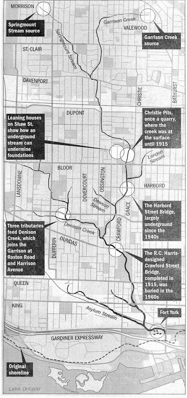
The walk started at Christie Pits and ended at Trinity Bellwoods Park (we live
near this park and had a tree planted there in memory of
our dog, KC)
and was about two hours.
 |
| Jon started by giving us some history of the creek |
As we walked, we could see how streets and houses were affected by Garrison Creek. We walked south on Grace Street and stopped by Bickford Park. It was part of a brickyard and where they got clay.
 |
| NE corner of Bickford Park |
 |
| A welcome sign of spring ... yay! |
 |
| Notice some houses are higher than others |
 |
| This accommodated the different water levels |
 |
| Heading south on Grace Street toward Harbord Street |
 |
| SE corner of Bickford Park |
 |
| South end of Bickford Park |
The Harbord Street Bridge was buried in the 1940s but a bit still remains above ground.
 |
| Today |
 |
| The part of the bridge that still exists |
We followed the sewers. This one was in Art Eggleton Park.
One level schools were built on top of the land covering the sewers ... it's city-owned land.
Heading south on Montrose Avenue to Crawford Street ...
These houses show how they were built for the different water levels ... some are on higher ground.
We stopped in Fred Hamilton Playground. The creek went through it and there was a bridge.
 |
| The path where the water flowed |
 |
| With the bridge |
 |
| Similar view today ... the four houses are still there |
In addition to following sewers, we also followed the Garrison Creek labels.
Some areas were built up ... like outside this house on Harrison Street (at Ossington Avenue). There is actually a level lower than the lowest one we see ...
 |
| This used to be street level |
Still following sewers, we headed south on Roxton Road.
 |
| There is one in the driveway ... notice the house is set off the road |
 |
| More sewers on the street |
 |
| More nearby in the park |
When the ground level was raised at the
Bellwoods Park House (at Shaw Street/Dundas Street W), the old trees were dug up, fill was added and the trees were replanted.
We crossed the Dundas Street W and headed south to
Trinity Bellwoods Park.
The
Crawford Street Bridge used to be at Dundas Street W/Crawford Street. It was buried in the 1960s.
 |
| Same spot today |
 |
| These old houses used to over look the creek |
 |
| Jon telling us how the Trinity College used to be in the park |
 |
St. Hilda's College, the women's college of the
University of Toronto, now a seniors' residence |
 |
| Four fire hydrants mark the corners of the old college |
 |
| Hearing about the oldest tree in the park |
 |
A brewery used to be where this block of buildings are ...
they were built on the brewery's foundation |
 |
| Another brewery was across the creek where the large apartment now is |
At the SE entrance of the park, there is a map of the creek.
This was an interesting walk. Jon was very knowledgeable and passionate about sharing the information.


2 comments:
Chris and I would totally have signed up for that tour, too!
Wow lots of people and what a beautiful day for a walk. Send me some of your sun PLEASE!!!!!
Post a Comment