Showing posts with label Jane's Walk. Show all posts

Sunday, 5 May 2019

Jane's Walk - Exploring Toronto's Niagara Neighbourhood, Toronto, ON

I did a Jane's Walk this afternoon.  I've done Jane's Walks in the past and have always enjoyed them.  There are hundreds of walks scheduled for this weekend every May.

Jane's Walk is a movement of free, citizen-led walking conversations inspired by Jane Jacobs (1916-2006), a writer, urbanist and activist who championed the voices of everyday people in neighbourhood planning and city-building. It encourages people to share stories about their neighbourhoods, discover unseen aspects of their communities, and use walking as a way to connect with their neighbours.


I did the Exploring Toronto's Niagara Neighbourhood walk, which is my 'hood.  It was led by Brett Willemsen.


On this walk, we'll be exploring Toronto's Niagara Neighbourhood, its history and the importance of park space in the area. Learn about the history of the Massey-Harris Manufacturing Company, the Smarties Company, and the Centre for Addiction and Mental Health (CAMH). As well as see some examples of great and not-so-great park spaces.

The walk started at 905 King Street W, the former Toronto head office of Massey Harris.  Only the building on the bottom right remains and it's now condos and the surrounding area are full of condos.

Then
Now

We then walked to Massey Harris Park, on the west side of the building.

Sunday, 4 May 2014

Jane's Walk - Landscape Archaeology of Garrison Creek, Toronto, ON

Gord and I did a Jane's Walk at 1:30pm today.

Jane’s Walk celebrates the ideas and legacy of urbanist Jane Jacobs by getting people out exploring their neighbourhoods and meeting their neighbours. Free walking tours held on the first weekend of May each year are led by locals who want to create a space for residents to talk about what matters to them in the places they live and work. Since its inception in Toronto in 2007, Jane’s Walk has expanded rapidly.

We did the Landscape Archaeology of Garrison Creek walk.

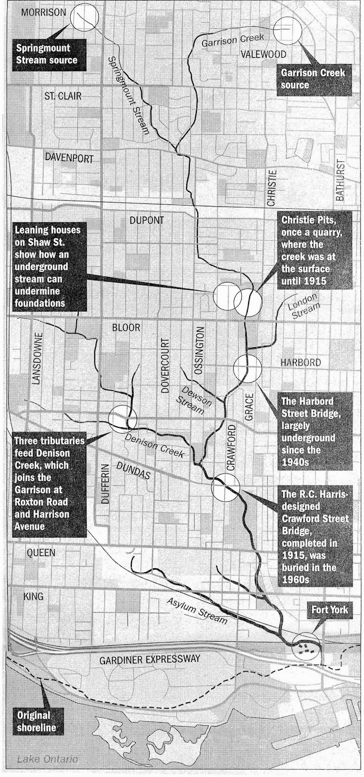
This walk is about finding clues that reveal the original topography. We're going to look at sewer grates, retaining walls, finish floor levels and trees in an attempt to reconstruct the vanished landscape.

The walk was led by Jon Harstone, an author and local historian who lives in the west end of Toronto. With a background in architectural history and archaeology, Jon is a former board member of Heritage Toronto and the former Chair of the Toronto Local Architectural Conservation Advisory Committee (LACAC).  We did a Heritage Toronto walk (Between the Bridge and the Brewery: Trinity Bellwoods Neighbourhood) with him a couple years ago that was very interesting.

http://humanriver.ca/about/garrison-creek/
First some history of Garrison Creek ...

The creek had its beginnings about 12,000 years ago when the last remnants of the Wisconsinan Glacier melted. The glacier had moved across this area for at least 60,000 years. It had wiped the land clear of forests and left deep deposits of glacial drift (sand, clay, gravel and stones) perhaps 200 feet thick. As the great ice sheet continued to melt back, the St Lawrence valley became free of ice and the waters in the Ontario basin dropped to a lower level. Garrison Creek then cut a longer course Lake Ontario.

Lieutenant Governor John Graves Simcoe founded Toronto when he established Fort York in 1793. At that time, Garrison Creek flowed in a large deep ravine with several tributaries to Lake Ontario. The creek had sparkling clear water and was famous for its salmon fishing. As the new town of York grew, breweries were built on the creek to take advantage of the clean water. Soon, other entrepreneurs developed land beside the creek such as abattoirs, market gardens, Trinity College and residential country estates. Dozens of bridges were built over the ravine.

By 1880, development along the ravine had polluted the creek. The City buried the creek in an underground sewer where it flows today. Later, the city gradually filled in sections of the ravine and demolished or buried the bridges.

The walk started at Christie Pits and ended at Trinity Bellwoods Park (we live near this park and had a tree planted there in memory of our dog, KC) and was about two hours.

Jon started by giving us some history of the creek

Saturday, 3 May 2014

Jane's Walk - Visions of Parkdale Past and Future, In the Balance, Toronto, ON

Gord and I did a Jane's Walk at 1pm today.

Jane’s Walk celebrates the ideas and legacy of urbanist Jane Jacobs by getting people out exploring their neighbourhoods and meeting their neighbours. Free walking tours held on the first weekend of May each year are led by locals who want to create a space for residents to talk about what matters to them in the places they live and work. Since its inception in Toronto in 2007, Jane’s Walk has expanded rapidly.

We did the Visions of Parkdale Past and Future, in the Balance walk.  We live near Parkdale so thought it would be interesting.  It started at Queen Street W/King Street W/Roncesvales and ended at King Street W/Atlantic and was about two hours.


Alec Keefer will lead us through what remains of the first lakeside Estates near King Street, then show us remnants of the mansions on Jameson. Where are they? We will see the middle class homes and institutions on Dunn and other streets. We will see the various pockets of blue collar housing. Why are they in these places? Alec will trace the changes in Spencer and Tyndall, leading us into Liberty Village, at the border of Parkdale. 

Jack Gibney will describe a vision of a beautiful historic village with increased housing, commercial and parking space and plans to preserve some beautiful buildings and make Parkdale the Paris of Toronto.

Our starting point

Alec Keefer led the walk.  He was very knowledgeable about the neighbourhood and passionate about sharing the information. He has lived in Parkdale for over 30 years and is the author of numerous books mostly on the architectural growth of this city. Jack developed the Parkdale Village Historical Society with Alec.

Jack and Alec

Before we started, they had everyone swear we wouldn't complain about the weather ... alas, that didn't work to hold off the rain.

Saturday, 4 May 2013

Jane's Walk - An Insider's View of Ossington, Toronto, ON

Gord and I did a Jane's Walk at 4:30pm today.

Jane’s Walk celebrates the ideas and legacy of urbanist Jane Jacobs by getting people out exploring their neighbourhoods and meeting their neighbours. Free walking tours held on the first weekend of May each year are led by locals who want to create a space for residents to talk about what matters to them in the places they live and work. Since its inception in Toronto in 2007, Jane’s Walk has expanded rapidly. In May of 2011, 511 walks were held in 75 cities in 15 countries worldwide. 

We did the An Insider's View of Ossington walk which was in our 'hood ... it was just over an hour.  We walked from Queen Street W north to Dundas Street W.

Think you're not 'hip' enough for this strip? Think again! Local bloggers from Ossington Village Blog will take you on a tour of the 'hood - showing you the hot spots you've read about and maybe some you haven't even heard of ... yet. We'll show off all the things that make our neighborhood a hot destination for dining, music, theatre, art, shopping and even more. Ossington Village, where entertainment starts!


Ossington Avenue is named after the ancestral Nottingham home of the Denison family, early landowners in the Ossington area. John Denison's 'Brookfield House' used to stand at the northwest corner of Ossington and Queen Street.

The first section of Ossington from Queen Street to Dundas Street was surveyed not long after the establishment of York in 1793. It was part of the original Dundas road, leading to London, Ontario. It was not until the War of 1812 that the road was built, after the Battle of York. During the 19th century, this section was developed as a commercial street. The Ontario Provincial Lunatic Asylum was opened at the foot of Dundas and Queen Street in 1850.

As Toronto expanded west and other retail facilities opened, the commercial section of Ossington south of Dundas became an area of industrial uses, including automotive repairs and storage facilities. By 2007, the low rents of stores along Ossington became attractive after rents along the Queen Street West increased. This led to an influx of bars, restaurants and stores.

We met at Ossington Avenue/Queen Street W, on the grounds of the Centre for Addiction and Mental Health (CAMH).


Jane's Walk - The Architectural Legacy of The Village of Parkdale 1879 – 1889, Toronto, ON

Gord and I did a Jane's Walk at 1:30pm today.

Jane’s Walk celebrates the ideas and legacy of urbanist Jane Jacobs by getting people out exploring their neighbourhoods and meeting their neighbours. Free walking tours held on the first weekend of May each year are led by locals who want to create a space for residents to talk about what matters to them in the places they live and work. Since its inception in Toronto in 2007, Jane’s Walk has expanded rapidly. In May of 2011, 511 walks were held in 75 cities in 15 countries worldwide. 

We did the Architectural Legacy of The Village of Parkdale 1879 – 1889 walk ... it was 1.5 hours.

Jack Gibney, of The Parkdale Village Historical Society and Meghan Edmonds, of the Roncesvalles Village Historical Society invite you on a trip down old Queen Street, to a time when life was slower, and less frantic. We will see examples of beautiful historic architecture, some in need of care and hear a tale of murder in 1894 on Jameson Ave. Learn the unusual origins of street names such as Tyndal, Spencer, as well as landowners O’Hara and Brock . Discover why Parkdale is one of the most historic and architecturally beautiful neighbourhoods of Toronto.


Parkdale is a neighbourhood and former village in Toronto, west of our 'hood.  Parkdale was founded as an independent settlement in the 1850s. It became an incorporated village in 1879 and later joined Toronto in 1889. It was an upper income residential area for the first half of the 20th century, with several notable mansions. The area changed dramatically with the building of the Gardiner Expressway in 1955, demolishing the southern section of the neighbourhood together with the Sunnyside Amusement Park, and the creation of a barrier between the neighbourhood and the lakeshore. This led to both an outflux of prosperous residents west and a decline in the local economy. Most of the residential buildings remain though many were converted into rooming houses but the demographic composition has changed considerably, including a higher proportion of lower incomes and newcomer families. Today, it is largely a working-class neighbourhood, with a mix of low and high income residents as well as new immigrants, and many artists and young professionals.

We started off at the corner of Queen Street W, King Street W and Roncesvalles.  There's the Eggsmart where Gord and I like to go for breakfast ... it used to be the Oceanview Hotel.


Sunday, 6 May 2012

Jane's Walk - Fort York and 200 Years of Development

Gord and I did the Fort York and 200 Years of Development Jane's Walk this afternoon.

This tour explores the evolution and history of Fort York, the Garrison Common and the Battle of York during the War of 1812 and the general development of the area. 

Starting at the canteen at Fort York National Historic Site, this special walking tour explores the evolution and history of Fort York, the Garrison Common and the nearby Lake Ontario shoreline. The tour highlights The Battle of York and its impact on the town of York (Toronto) as well as the subsequent fortification of the harbour, local railway & road building, and the eventual industrial, recreational and residential development of this vital area. 

You may discover a surprising blend of past and present in the historic landscapes surrounding the Fort. The walk centers on historic events, the war of 1812, and its connections to modern urban development. Free admission to Fort York following the walk. 

This is as we headed towards Fort York, from Strachan Avenue.  Five years ago the CN Tower was all alone!

Quite a contrast from the world of the early 1800s and today.


Our guide was René Malagón.

He has lived and worked in Toronto for the past 20 years. During most of that time he has worked as a Museum Programme Officer at Historic Fort York and other city run museums (E.D.C.). He has led walking tours in and around Fort York for several years and is still amazed at the dramatic changes that have evolved in the urban landscape of this historic section of the city.

René started by telling us what Fort York would have looked liked back in its day along with the surrounding area.


The fort was built by the British Army and Canadian militia troops in the late 18th and early 19th centuries, to defend the settlement and the new capital of the Upper Canada region from the threat of a military attack, principally from the newly independent United States.

During the War of 1812, on April 27, 1813 combined U.S. army and naval forces attacked York (Toronto)  from Lake Ontario, overrunning Fort York. As the British abandoned the fort, they set the powder magazine to blow up, killing or wounding several hundred U.S. soldiers.  The U.S. destroyed what was left of Fort York and burned much of the settlement of York, including the Parliament Buildings during their five–day occupation. 

Following several more U.S. raids over the summer, the British garrison returned to York and rebuilt the fortifications, most of which are still standing today. The rebuilt fort was sufficient to repel a further attempted invasion in 1814. The British Army occupied Fort York from 1793 to the 1850s and transferred it to Canada, which used it until 1932. The City of Toronto owned the Fort from 1903 onwards

René led us south, up and over the wall.  The original waterline used to be where the fence is at the bottom of the picture.  With all the landfill over the years, the lake is now a distance away, on the other side of the condos and through the trees.


This is looking northwest.


This is following the ten foot high wall, looking east.  Originally there was a 20 foot drop to the water on the south side of the wall.


Looking northeast ...


These pickets were supposed to impede the enemy.


Over the years, there hasn't been a lot of respect for Fort York.  At one point, there was a suggestion of putting streetcar tracks through the Fort so people could get to the Ex conveniently!!  They ended up being put through the north side of the Fort and are now gone.  In the 1950s, Fort York was almost torn down to make way for the Gardiner Expressway but highway planners eventually rerouted the elevated highway to the south of the grounds.


In the summer of 2006, while digging the base of one of the condo projects down by the water, construction crews discovered the remnants of Queen's Wharf which was buried for many years.  Pieces have been moved to Fort York.  The trees used for the wharf would be about 300 years ago.


René talked some more about Canada's part in the War of 1812.


Toronto has changed significantly since the early 1800s!


Over the years, industry moved in around Fort York ... and now condos are taking over the land the industries were on.


Contrasting old and new Toronto ...


Though the walk was scheduled for 1.5 hours, René invited anyone who was interested back to look at some old pictures.


It was a great walk!  René was very passionate and knowledgeable about Fort York and our involvement in the War of 1812.

One last note ... the military had owned about 1000 acres of land around Fort York, most of which west of the Fort.  This land was clear and flat so soldiers would be able to protect from attacks from the Americans from the opening of the Toronto Harbour, which at this time was west.  This is looking west now ... soldiers from that time would be amazed at the same view with all the condos and trees now in the way.  No sign of water at all


Saturday, 5 May 2012

Jane's Walk - Wellington Place: A Remarkable Neighbourhood Re-Emerges Over The Traces Of Two Centuries, Toronto, ON

Gord and I did a Jane's Walk this afternoon.

Jane’s Walk is a series of free neighbourhood walking tours that helps put people in touch with their environment and with each other, by bridging social and geographic gaps and creating a space for cities to discover themselves. Since its inception in 2007, Jane’s Walk has happened in cities across North America, and is growing internationally.

Jane Jacobs Jane Jacobs (1916-2006) was an urbanist and activist whose writings championed a fresh, community-based approach to city building. Her 1961 treatise, The Death and Life of Great American Cities, introduced ground-breaking ideas about how cities function, evolve and fail that now seem like common sense to generations of architects, planners, politicians and activists.

We did the Wellington Place: A Remarkable Neighbourhood Re-Emerges Over The Traces Of Two Centuries.

In 1793, Simcoe established both the Town of York and Fort York, which were neatly separated by military reserve lands. The extent of the reserve was based on how far a cannonball could be shot from the Fort. These reserve lands included Victoria Memorial Square – the military burial grounds. The Square is now a national historic site and part of the Fort York Heritage Conservation District.

In the 1830s, the government decided to build a second Fort, at what is now Exhibition Place, and to develop the military reserve as an extension of the town. The lands were divided into large lots with the intention of attracting the wealthy upper class away from the east end of the City, enticing potential buyers with a series of lush parks that bookended “Wellington Place”, the name given to this unique ensemble. The development of what was then known as St. Andrew’s Ward had begun, but a dramatic twist of economic fate changed the evolutionary path of the area, with effects still seen to this day.

In the 1850s, the railways acquired lands along the waterfront and pushed residential uses further north. For one hundred years industrial uses monopolized the area and warehouses, lofts and factories occupied the large lots that had originally been planned for residential villas making this area an industrial powerhouse. It then fell into a prolonged period of abandonment and disinvestment until the mid-1990s.

Then in a great testament to Jane Jacob’s thinking, a radical experiment called ‘Kings Regeneration Initiative’ was carried out under Mayor Barbara Hall in the mid-1990’s. Traditional land use controls were set aside so that four hundred acres in two former industrial districts flanking downtown were allowed to develop organically, each with a self defining mix of uses. Now a century and a half after the industrialization of the area, a mixed-use neighbourhood which is colonizing those obsolescent structures and adding new ones, is dynamically growing. Traces of the old plan remain, but change is the only constant. Victoria Memorial Square carries memories that go back to the city’s origins, and its story is now told through interpretative plaques and a renewed landscape design at the neighbourhood’s initiative including defining the historic burial ground with a granite border. Jane supported this effort and in 2002 wrote a letter commending the community’s efforts which is inscribed in a pair of chairs donated in her honour in the square.

The walk was led by Michael McClelland, Principal ERA Architects Inc., and Eti and Ken Greenberg, Wellington Place Neighbourhood Association, who are definitely passionate and knowledgeable about this neighborhood and were friends with Jane Jacobs.


We started in Victoria Memorial Square, hearing about the history of the park and the developments over the years.

Here are the chairs that were donated and dedicated to Jane's memory.


Then we walked to Draper Street, a couple blocks east, a 19th century residential street that had escaped the industrialization of the surrounding area.


Draper Street's empire-style cottages were built in 1881 and 1882, while its larger homes were constructed between 1886 and 1889. The street - a designated Heritage Conservation District - is unusual because its residential character survived the overall industrialization of the King-Spadina neighbourhood in the 20th century. Draper Street has been a haven for people of many backgrounds, such as Lincoln Alexander, who was born here in 1922 to West Indian parents, and who served as the first black Lieutenant-Governor of Ontario from 1985 to 1991. The name of the street honours William Henry Draper (1801-1877), a pre-Confederation lawyer and Conservative politician, who was the virtual 'Prime Minister' of the United Provinces of Canada from 1844 to1847. He subsequently became a judge, eventually being appointed Chief Justice of post-Confederation Ontario in 1869.


It's a quaint street.


A house had burnt down on the street at one time. Rather than rebuild, the land was made into a park for the street's residents. The Thompson family owns it and it will eventually be made into a pedestrian walkway linking the residents to Spadina Avenue.


We headed east again and heard about how laneways are being encouraged because by cutting up city blocks, it encourages residents to interact more.


We finished in Clarence Square.


Clarence Square is one of the oldest remaining park spaces in the downtown core of Toronto. The park became a largely neglected space when the rail yards and industrial warehouses inhabited areas adjacent to the park. There is an initiative to revitalize the park in the next couple of years.


These row houses were built in the late 1800s and eventually fell into disrepair. A few years ago, an architect took it on as her project to fix up some older buildings in the city and this was one of her projects. She did a great job ... I thought they were built in the the 1960s.


It was our first Jane's Walk we'd done and we enjoyed it.